Story by Jack Lee
While California’s reservoirs are currently 116% of normal for this time of year, other signs of drought are quickly creeping in. The reason: July’s extreme heat.
“We’ve supercharged our drying,” said John Abatzoglou, a climatologist at UC Merced.
Over the past few weeks, the atmosphere has been extremely thirsty, Abatzoglou said, pulling out large amounts of moisture from live vegetation and dead fuels.
The indicator points to increased fire risk, beyond grasslands into higher elevation forests.
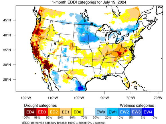
Scientists refer to this thirst as evaporative demand. The map above shows how anomalous the demand for atmospheric moisture was from June 20 to July 19, compared with the same period from 1979 to 2016.
The Central Valley is shown in dark red, indicating a level of dryness that occurred less than 2% of the time in the past 38 years.
“It accelerates how quickly our fire season is going to get going,” Abatzoglou said.
U.S. Drought Monitor maps also indicate the return of drought to California. Over just a few weeks, moderate drought emerged along the state’s border with Oregon.
Scientists describe such a rapid intensification or development of drought as “flash drought,” akin to flash floods caused by sudden downpours. Flash drought is generally defined as an increase in drought severity of at least two U.S. Drought Monitor categories in four weeks, said Brian Fuchs, a climatologist with the National Drought Mitigation Center at the University of Nebraska.
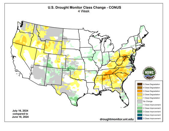
This map shows how drought intensity has changed across the country over the past four weeks, with increases in severity in yellow and orange. Places where drought conditions improved are shown in green.
The far Northern California region in dark yellow jumped from normal to abnormally dry to moderate drought in just a few weeks: “You could argue that that is a flash drought developing in that area,” said Fuchs, who prepared the past two U.S. Drought Monitor maps.
Rapidly changing conditions could ramp up the region’s susceptibility to wildfires, Fuchs explained, and there could also be impacts to natural ecosystems.
California has already faced an extremely active early wildfire season, with around 287,000 acres burned across the state as of July 24. The five-year average is less than half that, about 118,000 acres.